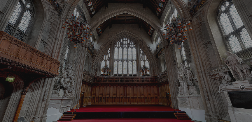
Inside London's Guildhall in 3D
How we digitised the Great Hall — and why a precise digital record matters for preservation, research, and public storytelling.
Why digitise our heritage?
A precise digital record ensures that the architectural and decorative details of the Great Hall are accurately documented for the future. In the event of a natural or man-made disaster, this data provides crucial references for reconstruction and conservation. In addition, integrating the 3D model into Building Information Modelling (BIM) enables structural analysis, helping conservationists monitor the building's condition over time and detect signs of deterioration.
Beyond digital preservation & documentation, a digital model becomes a powerful tool for education and storytelling by transforming the Great Hall into an interactive experience. The statues, stained glass windows, and architectural embellishments depict significant figures and events which can be brought to life through digital storytelling, offering deeper insights into London's rich history.
These features also serve as narrative gateways to broader historical themes, such as medieval trade guilds, the governance of the City of London and democracy in general, and the impact of events like the Great Fire of London.
Benefits also extend beyond historical storytelling. A digitised Guildhall can be made accessible to researchers and the public worldwide, ensuring that its history reaches beyond those who can visit in person. Advanced analysis techniques, including artificial intelligence, could further reveal artistic patterns, inscriptions, or lost details, contributing to ongoing academic research. By combining high-precision 3D documentation with immersive storytelling, the digital Guildhall becomes both a vital heritage asset and a dynamic educational resource, bridging the past with the present in meaningful and engaging ways.
How was it done?
Combining photogrammetry with laser scanning techniques yields a synergistic 3D dataset that capitalizes on the strengths of both methods. Laser scanning provides precise and high-resolution spatial measurements, capturing the geometry of the structure with exceptional accuracy. This technology creates a dense 'point cloud' that details the contours and dimensions of surfaces, regardless of lighting conditions.
Photogrammetry excels in capturing detailed colour and texture information by analysing overlapping photographs from multiple angles. When these datasets are merged, the laser scanner's geometric precision is enhanced by the photogrammetry's rich, photorealistic textures.
The integration process involves aligning the point clouds from the laser scans with the imagery-derived data, using control points and calibration techniques. This fusion results in a comprehensive digital model that is not only dimensionally accurate but also visually detailed. Such a dataset is invaluable in heritage conservation, engineering analysis, and digital storytelling, as it creates a true-to-life representation of the structure. By leveraging the complementary capabilities of both techniques, the final model supports detailed analysis, precise measurements, and immersive visualizations, creating a best-case standard for 3D documentation.